Home page
» NAKHCHIVAN
» General information
General information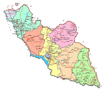 About the Nakhchivan Autonomous Republic General Information During 1920-1923 it was called as Nakhchivan Soviet Socialist Republic, in 1923-1924 as Nakhchivan Autonomous region, in 1924-1990 as Nakhchivan Autonomous Soviet Socialist Republic, since 1990 the Autonomous Republic of Nakhchivan - autonomous state within the Republic of Azerbaijan. It has borders in the north and east with the Republic of Armenia (border line is length 246 km), in the west and south with Turkey (15 km) and in the south with the Islamic Republic of Iran (204 km). Natural border of Nakhichevan Autonomous Republic with Armenia makes the Zangezur and Daralayaz water lines, and the border with Turkey and Iran - Araz River Territory The territory of the Autonomous Republic is 5.5 thousand kv.km. According to information of the year 2009, the Nakhichevan Autonomous Republic has a population of 400 000 people. Administrative Division Of the subordinate cities: Julfa, Nakhichevan, Ordubad Nature Small part of the territory of the Autonomous Republic is covered with Zangazur and Daralayaz ridges of the Lesser Caucasus and their tributaries extending towards the Araz River valley and forming middle and low mountainous areas in relief. Zangezur range is the highest ridges of the Lesser Caucasus; Gapijig is its the highest peak (3906 m), and at the same time is the highest peak of Lesser Caucasus in the territory of the Republic of Azerbaijan and located always 41 meter above of snow line. Climate of Nakhchivan is sharp continental. Dry subtropical climate type can be found in the Ordubad region. Absolute minimum temperature is -31C (Dervishlar), and the absolute maximum temperature is 44C (Julfa).

|