Home page
» TERRITORY
» National territories
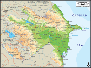
National territories In Asian continent the area located between south hill of Baqrau (Boqrov) mountains till Samur River valley as well as from western coast of the Caspian Sea to the west coast of Lake Urmia is called Azerbaijan. Its total area is 200 000 km2. It stretches from Taman peninsula in the Black Sea up to Absheron for 1500 km. The state uniting its south-east, bigger part of the Lesser Caucasus, the Kura-Araz lowland, Talish Mountains, Savalan, Karadagh, Bozqush range and part of the Iran plateau is Azerbaijan. - The country is located between 39° 24 \', 41° 54\' north latitude and 44 ° 46 \', 50 ° 45\' east longitude, but he capital Baku is located on the 40 ° parallel. It expands for 500 km from west to east, and 400 km from north to south. The time difference between West and East is 24 minute. At present, the area of Azerbaijan is 86,6 thousand km2. Its 20% is under Armenian occupation. Far points: 2. South - Astarachay 3. East - Seal bay (in sea Oil rocks) 4. West - Jandargol (in Nakhichevan - Sadarak) Neighbors: State borders in south with Iran is 765 km and with Turkey is 15 km, from north with Russia is 390 km, from north-west with Georgia is 480 km, from west with Armenia is 1007 km. Sarısu - 67.0 sq.km Aghgol - 56.2 sq.km Aghzıbirchala - 37.0 sq.km Boyukshor - 9.2 sq.km Hajiqabul - 8.4 sq.km The biggest saline lake in the world – The Caspian Sea - area 400000 sq.km, depth-1025 m. The length of widest area of the Caspian Sea in Azerbaijani sector is 456 km. The border with the Caspian Sea is 825 km from Samur River to Astarachay River. The highest mountain peak - Bazarduzu - 4466 m. Big islands: Pirallahı - 14.4 sq. km Chilov - 11.5 sq. km Khara -Zira - 3.5 sq. km Big -Zira - 1.4 sq. km Big rivers: The Kura – 1515 km Arax – 1072 km Alazan (Qanykh) – 413 km İori (Gabirry) – 389 km Samur – 216 km Tartar – 200 km
|
