Home page
» GEOGRAPHY
» Physical Geography
» Relief
Relief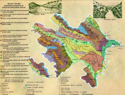 There are two main forms of relief in Azerbaijan: mountains and plains. The biggest geomorphological units the Great Caucasus, Lesser Caucasus, Talysh Mountain surround the Kura-Araz lowland from the north, west and south-east areas. The average altitude in Azerbaijan is 657 m. Bazardyuzy is the highest peak from the sea level - 4466 m, the low point is in the Caspian lowlands - (-28 m). Height amplitude reaches 4466 +28 = 4494m.
The Greater Caucasus enters in Azerbaijan from Tinov- Rosso top and gradually descends and passes to plain in the Absheron peninsula, and from there divides the Caspian Sea in two sections and reaches Turkmenistan in the form of underwater ridges. In watershed range till Babadag (3629 m) it is characterized by relief of the glacier. In this area Bazardyuzy (4466), Tufandagh (4191 m), Bazaryurd (4126 m), Yarıdag (4116 m), Chingiz Mustafayev (4063 m), etc. peaks are located.
In parallel with the watershed range in south Niyal –Qovdag and in north Yan ridge extend. Its highest peak Shahdag is at 4243 meters (Ataturk 3750 m). Towards north-east Gusar plain and Samur-Devechi lowland descends.
Towards south from Babadag the mountains are more fragmented, descended. Salavat pass - 2915 m, Dubrar- 2205 m, Gadi - 1222 meters. Its continuation is replaced with Gobustan depression (up to 1000 m) and the Absheron hilly plain.
As magmatic-intrusive rocks dominate in the Lesser Caucasus it was less dissected. Watershed and the foothills are subdued.
Shahdag, East Goycha (Sevan) chain comprise border with Armenia. Murovdagh mountain chain stretches to the east from them. Its highest peak is Gamısdag at 3724 meters.Its southern slope is more sheer. From Murovdagh towards south-east Garabakh range extends until the Araz River. The great Kirs peak (2725 m) is here. Between border with Armenia and Upper Garabakh ridge the Garabakh volcanic plateau is located. Here volcanic products of the fourth period are dominated. Extinct volcanic cones, peaks - Gizilboghaz (3581 m), Ishigly (3552 m), Dalidagh (3616 m), etc. rises. Here.
The north slope of the Murovdagh ridge is less inclined and smooth. Ganja - Gazakh steppe is situated here.
The plains along the Araz are located at height of over 600m.
Talysh Mountains are located in the south-east of Azerbaijan. It consists of three ranges: Talysh, Peshtasar, Boruvar. Its highest peak is Gomurgoy - 2477 m, Qızyurdu is at 2433 meters. Lankaran lowland is located between the Caspian Sea and Talysh. Mountains.
Kur-Araz lowland is located between the Greater and Lesser Caucasus Mountains, and is expanding to the east. 40% of plain extended towards the Caspian Sea is located below the level of the ocean.

|